Miami Adds Incentives For High-Rises Up To One Mile From Rail Stations

Miami has approved a new zoning initiative allowing for higher-density development within up to a one-mile radius of current and planned Metrorail, commuter rail, and Brightline stations within city limits.
The plan permits developers to propose high-rise residential and commercial projects with far more height and housing units than previously allowed, aiming to increase housing supply, improve affordability, and promote transit usage.
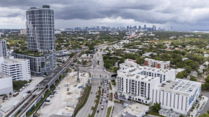
Aerial view of the Douglas Road Metrorail station on Thursday, Aug. 7, 2025, in Miami. City of Miami officials recently approved the Transit Station Neighborhood Development program, which will allow for increased development and affordable housing within a mile of each station. (PHOTO CREDIT, Matias J. Ocner, Miami Herald)
Previously, Miami 21’s “transitional zoning” rules limited building height near low-scale residential neighborhoods. However, the new “Transit Station Neighborhood Developments” (TSND) could override those protections, warned planning board member Paula De Carolis, who voted against the proposal.
At a June public hearing, residents and board members raised concerns about the expanded transit zones—extending up to a full mile from stations—arguing that such distances exceed typical walkability standards for transit-oriented development, which usually caps at a half-mile. Critics say the wider radius could spur excessive high-rise construction across large parts of the city without meaningful transit connectivity.
“I think the one mile is going to create a lot of problems,” said planning board member Paul Mann. Coconut Grove resident Kim Hogan called the idea of walking a mile in Miami’s heat “insane,” emphasizing how unrealistic the plan is for pedestrians.
Despite pushback, the planning board narrowly voted 6-3 to recommend approval, and the Miami City Commission gave final approval on July 24.
City planning director David Snow and assistant planning director Sevanne Steiner defended the program, telling the Miami Herald that most new density and building height will concentrate closer to stations, with tapering scale beyond the half-mile mark. They described the initiative as a gradual, controlled approach to urban growth.
The approval process is complex. It first requires a land-use amendment under the city’s comprehensive plan. Then, a “transit-node” designation must be approved based on how much development an area can support. Developers can then submit either a “general” or “enhanced” TSND plan, specifying building height, density, proximity to stations, and required public benefits.
Enhanced TSND projects face significant requirements, including station improvements, master planning, new streets, pedestrian paths, bike infrastructure, or shuttle services. These demands mean only well-funded developers capable of delivering large-scale urban neighborhoods are likely to pursue them. As a result, only select areas in the city may realistically accommodate such intensive development.
Source: Miami Herald

